
Achievements of the Land Information Council of Jamaica |
|||||||||||||||||||||||||||||||||||||||||||||||||||||||||||||||||||||||||||||||||||||||||||||||||||
GIS Education and Training |
|||||||||||||||||||||||||||||||||||||||||||||||||||||||||||||||||||||||||||||||||||||||||||||||||||
|
The Council recognized that trained GIS personnel are needed if the technology was to be used efficiently and effectively in Government. A major objective of the Council was to develop a cadre of personnel with the necessary skills to maximize the use and benefits of GIS and related technologies. An early accomplishment was the creation of short term GIS training courses including, Executive GIS, Introduction To Geographic Information Systems, Introduction to ArcView and Extensions, Data Analysis, Data Automation, Database Design and Implementation and Developing and Managing a GIS. More |
 |
||||||||||||||||||||||||||||||||||||||||||||||||||||||||||||||||||||||||||||||||||||||||||||||||||
GIS In Schools Programme (GISSEP) |
|||||||||||||||||||||||||||||||||||||||||||||||||||||||||||||||||||||||||||||||||||||||||||||||||||
|
The GIS in Schools Education Programmme (GISSEP) was launched on February 14, 2002. This was made possible through a US $1million grant (in GIS software, technical support and training material) provided by Environmental Systems Research Institute (ESRI), the world’s leading GIS software provider, members of the Council, the SDMD and public and private sector volunteers. The GIS Training/GIS In Schools Sub committee of the LICJ and the SDMD coordinates the programme. ESRI also provided 30 computers that were shipped free of charge by Air Jamaica and distributed to the schools enrolled in the programme. More |

|
||||||||||||||||||||||||||||||||||||||||||||||||||||||||||||||||||||||||||||||||||||||||||||||||||
Spatial Datasets |
|||||||||||||||||||||||||||||||||||||||||||||||||||||||||||||||||||||||||||||||||||||||||||||||||||
|
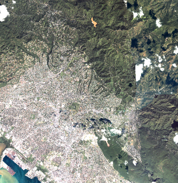
The LICJ actively coordinates the development of strategies and proposals, identifies resources and methodologies to facilitate the creation and maintenance of geospatial data “framework data sets” for the island. To facilitate the creation of framework data sets, access to and availability of base maps is fundamental. The LICJ coordinated the purchase of 1:4800 satellite image maps of the entire island and 1:2000 maps for the urban areas of Kingston and St. Andrew, Portmore, Spanish Town, Port Maria and Montego Bay. More |
|
||||||||||||||||||||||||||||||||||||||||||||||||||||||||||||||||||||||||||||||||||||||||||||||||||
Virtual Reference System (VRS) For Jamaica |
|||||||||||||||||||||||||||||||||||||||||||||||||||||||||||||||||||||||||||||||||||||||||||||||||||
|
The LICJ in collaboration with the National Land Agency (NLA) and the National Water Commission (NWC) established an active geodetic network of thirteen (13) continuously operating reference (COR) stations based on global positioning systems for the island. The network provides real-time positioning information at centimeter accuracy. A major project of the Council is the establishment of a comprehensive VRS network of thirteen GPS stations across the island. The total estimated costs to create the network is JA$45,000,000. The Jamaica GPS/VRS Network is a configuration of high precision Global Positioning System (GPS) base stations that provide real-time and post processed corrected positional data to mobile and traditional fixed GPS users such as Land Surveyors and Engineers for a fee. GPS services are presently used for cadastral (the Land Administration and Management Programme, LAMP), topographic, hydrographic and engineering surveying, bauxite and mining operations and spatial data collection. GPS can also be used in the areas of; machine control, earth moving, urban and municipal mapping, environmental monitoring, automatic vehicle tracking and location systems, asset and facilities management and navigation. |
|||||||||||||||||||||||||||||||||||||||||||||||||||||||||||||||||||||||||||||||||||||||||||||||||||
Policies and Standards |
|||||||||||||||||||||||||||||||||||||||||||||||||||||||||||||||||||||||||||||||||||||||||||||||||||
| a) | In 2006, Cabinet approved the adoption and implementation of the thirteen (13) principle Metadata Guidelines by all government agencies who are creators and users of geospatial data. | ||||||||||||||||||||||||||||||||||||||||||||||||||||||||||||||||||||||||||||||||||||||||||||||||||
| b) | In 2006, the NSDI Strategic Plan was prepared. | ||||||||||||||||||||||||||||||||||||||||||||||||||||||||||||||||||||||||||||||||||||||||||||||||||
| c) | In 2010, Cabinet approved the establishment of the National Emergency Response Geographical Information Systems Team (NERGIST) and the guidelines governing its operations. | ||||||||||||||||||||||||||||||||||||||||||||||||||||||||||||||||||||||||||||||||||||||||||||||||||
| d) | In June 2014, NERGIST was officially launched and over forty-five (45) individuals have been trained and certified. | ||||||||||||||||||||||||||||||||||||||||||||||||||||||||||||||||||||||||||||||||||||||||||||||||||
| e) | In 2015, the Government of Jamaica signed an Enterprise Licence Agreement (ELA) for GIS software. | ||||||||||||||||||||||||||||||||||||||||||||||||||||||||||||||||||||||||||||||||||||||||||||||||||
Special Achievement in GIS Awards |
|||||||||||||||||||||||||||||||||||||||||||||||||||||||||||||||||||||||||||||||||||||||||||||||||||
| 1. | Environmental Systems Research Institute (ESRI) Special Achievement in GIS (SAG) in recognition of the coordination of National GIS activities in 2001. | ||||||||||||||||||||||||||||||||||||||||||||||||||||||||||||||||||||||||||||||||||||||||||||||||||
| 2. | ESRI SAG Award in recognition of outstanding work done under the GIS in Schools Education Programme (GISSEP) in 2005. | ||||||||||||||||||||||||||||||||||||||||||||||||||||||||||||||||||||||||||||||||||||||||||||||||||
| 3. | 1st URISA Caribbean Spatial Vision Award for extraordinary achievement in GIS within the Caribbean in 2008. | ||||||||||||||||||||||||||||||||||||||||||||||||||||||||||||||||||||||||||||||||||||||||||||||||||
| 4. | ESRI SAG Award in recognition of GIS Best Practice Implementation in 2016. | ||||||||||||||||||||||||||||||||||||||||||||||||||||||||||||||||||||||||||||||||||||||||||||||||||